Avalon Park, Orlando, Florida  ·  A Local History

The Town That Planned Everything but the Power


East of Orlando, a Swiss banker built a whole town from scratch on open cattle land — a place designed so you’d never have to leave it. It was only a few years old when three hurricanes crossed Central Florida in six weeks, and the newest town in the county went as dark as the oldest.

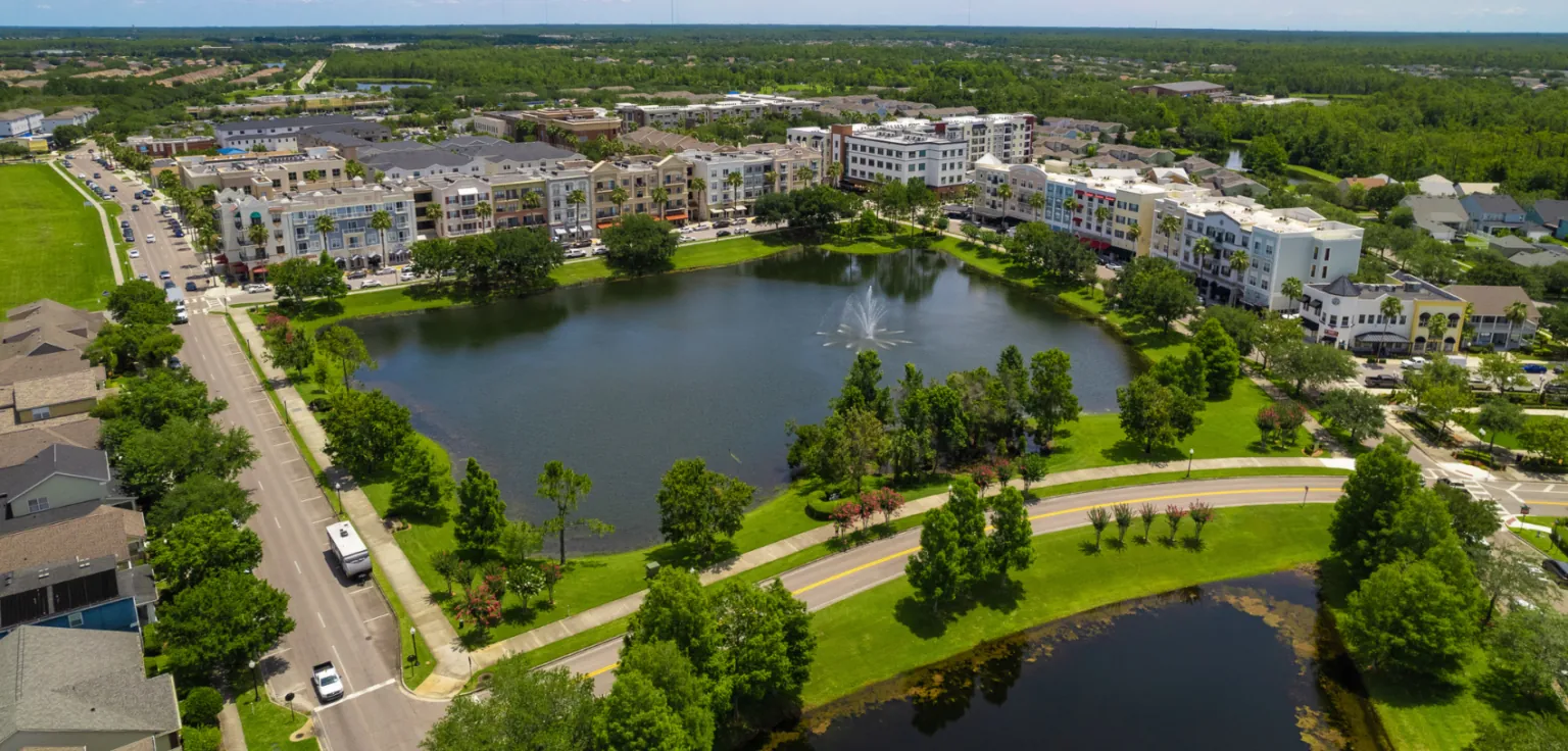
An aerial view of Downtown Avalon Park: a ring of four- and five-story mixed-use buildings around a man-made lake with a fountain, streets lined with parked cars, green lawns and curving roads, and dense woodland stretching to the horizon.
A whole downtown, where the map used to say pasture
Downtown Avalon Park from the air. A town center, a lake, a fountain, apartments over shops — all of it built since 1998 on open land east of Orlando. Photograph via Avalon Park Orlando (avalonparkorlando.com).

The man who built this town likes to say that when he started, there was nothing out here but cows. He is close to right. In 1998, on 1,860 acres of flat pasture past the eastern edge of Orlando’s sprawl, a Swiss banker named Beat Kahli began building an entire town where none had ever been — streets, schools, a downtown, a man-made lake with a fountain in the middle of it, and eventually tens of thousands of people.

The whole idea was that you’d never need to leave. Live, learn, work and play, all inside the walk of a few blocks. And for its first few years it worked exactly like the brochure — right up until the summer the sky decided to find out whether a town can really stand on its own.

It really was just cows

Before any of it, this was the far southeast corner of Orange County: cattle land and pine flatwoods, hemmed on its eastern side by the Econlockhatchee River — a slow, tea-colored Florida river the locals just call the Econ. It is the kind of place where, until very recently, the most frequent traffic was livestock.

A herd of cattle standing on a grassy bluff above a bare, cracked riverbank under a big blue Florida sky with scattered cumulus clouds, seen from the water of the Econlockhatchee River.
Cattle on the Econ — the land before the town
Cows along the Econlockhatchee River. This is the country Avalon Park was laid over: open pasture at the eastern edge of Orange County. Photograph by Trougnouf (Benoit Brummer), via Wikimedia Commons.

Kahli’s company, the Avalon Park Group, was founded in 1995, and by one account he did something unusual before he poured a single sidewalk: he sold off most of the land. Of a much larger original holding, thousands of acres went to the county and the local water-management district as preserve and drainage, which left the river edge wild and let him start building the town itself without carrying a mountain of debt.

A quiet, tannin-dark river curving between densely wooded banks of palms, oaks and cypress, seen from a footbridge on the Florida Trail.
The Econ — the one edge they left alone
The Econlockhatchee River from the Florida Trail bridge. The river forms Avalon Park’s eastern boundary — a strip of real Florida wild kept at the back door of a built-from-scratch town. Photograph by Trougnouf (Benoit Brummer), via Wikimedia Commons.

So the ingredients were strange from the start: a European financier, a square of Central Florida cowfield, a wild river on one side, and a plan to conjure a complete American town out of all of it in a single sustained push.

A town you’d never have to leave

What went up wasn’t a subdivision. It was designed on the principles of New Urbanism — the deliberately old-fashioned idea that a town should have a real center you can walk to, with homes, shops, offices and schools mixed close together instead of marooned in separate pods connected only by car.

The downtown came first as a gesture: a clock tower, raised in 2000, standing over not much yet. Then the buildings filled in around it — a first downtown block in 2002, then more — four- and five-story facades in sherbet colors, apartments stacked over storefronts, a lake dug and shaped as the town’s front yard, with a fountain planted in the middle of it.

A ground-level view across Avalon Park's downtown lake toward a row of pastel four-story mixed-use buildings with awnings and balconies, a tall American flag on the left and a fountain spraying from the lake.
The front yard of a town that didn’t exist in 1997
Downtown Avalon Park across its lake. Apartments over shops, a walkable center, a fountain on a man-made lake — the New Urbanist pitch made concrete. Photograph via Avalon Park Orlando (avalonparkorlando.com).

The sales line was “live, learn, work and play,” and it was meant literally. The promise of a place like Avalon Park is a kind of independence: everything you need, inside your own walls and sidewalks, so the wider world and its hassles can stay out past the tree line. Build it right, and you’ve designed your way out of needing anyone.

The one thing you can’t build from scratch

Except for one thing. You can lay your own streets and raise your own school and dig your own lake. You cannot make your own electricity. The power that runs the lights, the air conditioning, the water pumps, the traffic signals and the fountain all comes in on wires strung from somewhere else — across the same open country the town was carved out of.

A town can be built to need nothing from the outside world and still depend, completely, on a line of poles marching in from it.

For a new town in Central Florida, that dependency has a season. Every summer the afternoon thunderheads build into the tallest storms in the country, and this stretch of the state gets struck by lightning more than any other. The wires that feed a town like Avalon Park run right through all of it. It was only a matter of time before something larger than a thunderstorm came up the peninsula to test them.

2004: three in six weeks

It came in 2004, and it didn’t come once. In a span of six weeks, three hurricanes crossed Central Florida — a sequence so improbable that people who lived through it still measure other storm seasons against it.

A NASA true-color satellite image of Hurricane Charley as a tight white spiral with a visible eye, sitting against the whole Florida peninsula on August 13, 2004.
Charley over Florida — Aug. 13, 2004
Hurricane Charley on August 13, 2004. A NASA Terra/MODIS image taken as Charley bore down on Florida’s southwest coast. That night its eye tracked northeast, straight across Orange County and over Orlando. Image: Jacques Descloitres, MODIS Rapid Response Team, NASA/GSFC.

Charley made landfall on the southwest coast on August 13 as a compact, violent Category 4, then turned up the middle of the state. In the early hours of August 14 its eye passed directly over Orlando; the airport recorded sustained hurricane-force winds. For a region that tells itself it is safely inland, it was a direct hit.

Three weeks later, over Labor Day weekend, Frances crossed from the Atlantic side, enormous and slow, and dragged across the peninsula for the better part of two days. Three weeks after that, on the last weekend of September, Jeanne came ashore almost exactly where Frances had and crossed Central Florida again. Each storm, on its own, knocked out power to roughly a million people. Back to back to back, they left crews and residents doing it all three times.

A map of the 2004 Atlantic hurricane season showing the looping tracks of every storm as colored dotted lines, with several converging on the Florida peninsula.
One season, and Florida kept ending up under the line
Every track of the 2004 Atlantic hurricane season. Charley, Frances and Jeanne (along with Ivan on the Gulf coast) all found Florida within weeks of one another. Map by Supportstorm, using NHC data, via Wikimedia Commons.

What a storm does to a brand-new town

Where Charley came ashore, at Punta Gorda, whole mobile-home parks were reduced to splinters. The town Avalon Park was modeled against — older, built of sturdier Florida stock — fared better than that. But sturdiness and the grid are two different questions. Across Central Florida the storms did the same thing everywhere: they put the wires on the ground.

An aerial view of a Florida mobile-home neighborhood flattened by Hurricane Charley: homes torn open to their frames, roofs and walls scattered as debris across lawns and streets.
Punta Gorda — where Charley came ashore
Charley’s landfall damage at Punta Gorda, August 2004. This is the coast where the storm came in before it crossed the state to Orlando. FEMA photo by Andrea Booher, via Wikimedia Commons.

And here the shiny, self-contained new town and the oldest trailer park ended up in exactly the same boat. When the line down the road is lying in the street, it does not matter how new your house is, how walkable your downtown is, or how complete your plan was. Without the wire, the air conditioning stops, the refrigerator warms, the pumps quit, and the fountain in the middle of the lake goes still. The newest town in the county went as dark as the oldest.

Looking up at a lineman in a white hard hat working from a bucket truck high on a wooden utility pole beside a palm tree, under a bright blue sky.
The only thing that ends an outage — a crew on the pole
A line crew repairs storm-damaged poles, September 2004. After Frances crossed the state, restoring power meant exactly this, pole by pole, for days to weeks. FEMA photo by Mark Wolfe (Fort Pierce, Florida), via Wikimedia Commons.

Getting it back was not a design problem a planner could solve in advance. It was crews in bucket trucks, one pole at a time, spread impossibly thin across a whole state that had been hit three times in six weeks. For Central Florida, the lights came back in days for some and weeks for others — and there was nothing a resident could do but wait for a truck to reach their street.

The thing you can’t walk to

That is the quiet lesson buried in a town built to need nothing. Avalon Park really did think of almost everything. You can walk to the school, the shops, the office, the lake. The one errand the design can never remove is the one that matters most when a storm hits: you cannot walk to electricity. It arrives from outside, or it doesn’t arrive at all.

Stand in Downtown Avalon Park today — the fountain running, the shops open, the whole improbable town humming along as if it had always been here — and it looks like a place that planned for everything. It very nearly did. The one thing it left to the weather is the same thing every Florida town leaves to the weather, and the only question a hurricane ever really asks a place is how long it can go without an answer.

A present-day note · GENERasic

Avalon Park could plan the streets, the school and the lake. The one thing no town plan erases is that the power comes in from outside — and a storm can put it on the ground in an afternoon.

In 2004, the answer for most of Central Florida was “days for some, weeks for others” — because restoring a grid hit three times in six weeks came down to how fast a crew could reach your particular street. That part was never in a resident’s hands.

A single house runs on electricity exactly the way that town does. Cooling, clean water, refrigeration, a CPAP at night, medical equipment — nearly everything that keeps a home livable needs power, and in a storm the grid is the first thing to go. In Florida that’s a when, not an if. No amount of good planning or new construction keeps the lights on when the line down the street is lying in the yard.

A standby generator is the one piece of that you can decide ahead of time. It doesn’t wait on a bucket truck working its way across the county — it starts itself the moment the power drops, whether anyone’s home or not. In a Florida outage, here’s what it’s actually holding up:

An enclosed residential standby generator on a concrete pad beside a building, with trees behind it.
The fallback, wired before you need it
A residential standby generator (representative photograph, not Avalon Park equipment) — wired to start on its own the moment the grid drops. Via Wikimedia Commons.

Which of those actually apply to your address — your medical needs, how your house is fed, well or city water — is worth pinning down for your own home rather than guessing. That part is yours to check.

You can get an address-specific installed price for standby power — the whole turnkey number, not a callback and a maybe — in one sitting.

Get your installed price for this address→
Sources & Photo Credits

On the history

Note on the chosen lens and on uncertainties

This page was built with a “power resilience” lens for GENERasic. Unlike an old city, Avalon Park has no deep archive — it is a planned community built since 1998 — so the strongest true, power-centered story here is the collision between its founding ambition (a self-contained New Urbanist town designed so residents would never have to leave) and the 2004 hurricane season, when three storms crossed Central Florida in six weeks and the regional power grid went down for days to weeks. A few points are stated carefully. Founding and build dates: the Avalon Park Group (1995) and the 1,860-acre, 1998 start are corroborated by Orange County and Wikipedia; the specific downtown milestones (Clock Tower 2000, Downtown I 2002, Downtown II 2005) are developer- and real-estate-sourced, not from an independent archive, and are described that way. “It was just cows”: that the land was pasture/cattle country is Kahli’s own characterization, consistent with the area’s rural southeast-Orange-County history; the page attributes it to him rather than asserting it as a documented land-use record. Land sold off: the account that Kahli sold thousands of the original acres to the county and water-management district (leaving the Econ edge as preserve and letting him build debt-free) comes from a 2000 CNU profile and is attributed as “by one account.” Population: figures vary widely by boundary — a Census estimate of roughly 14,000 for the core versus developer/press figures around 60,000 for the greater Avalon Park area — so the page says only “tens of thousands” rather than a single number. Hurricane specifics: Charley’s path over Orlando and the hurricane-force winds at OIA are from the NHC report; the “roughly a million without power” per storm and the “days to weeks” restoration are from contemporary coverage and are given as regional, Central-Florida figures — no Avalon-Park-specific outage duration is claimed, because none was independently verified. The Punta Gorda damage photo is labeled as Charley’s coastal landfall, not Avalon Park; the line-crew photo is labeled as post-Frances Florida restoration, not Avalon Park.

Photographs

  1. Downtown Avalon Park aerial (hero, modern) — the town center ring and man-made lake with fountain, seen from the air. Via the Avalon Park Orlando community site. File: avalon-park-downtown-aerial-today. avalonparkorlando.com
  2. Cows along the Econlockhatchee River (modern) — cattle on a bluff above the riverbank, the open country Avalon Park was built over. Photograph by Trougnouf (Benoit Brummer). File: econlockhatchee-river-cows-pasture. Wikimedia Commons
  3. Econlockhatchee River from the Florida Trail bridge (modern) — the wooded, tannin-dark river that forms the town’s eastern edge. Photograph by Trougnouf (Benoit Brummer). File: econlockhatchee-river-florida-trail-bridge. Wikimedia Commons
  4. Downtown Avalon Park across its lake (modern) — pastel mixed-use buildings, flag and fountain on the man-made downtown lake. Via the Avalon Park Orlando community site. File: avalon-park-downtown-lake-today. avalonparkorlando.com
  5. Hurricane Charley over Florida, August 13, 2004 — NASA Terra/MODIS true-color satellite image. Jacques Descloitres, MODIS Rapid Response Team, NASA/GSFC (public domain). File: hurricane-charley-satellite-2004-08-13. Wikimedia Commons
  6. 2004 Atlantic hurricane season track map — every storm track of the season, several crossing Florida. By Supportstorm, from NHC data (public domain). File: 2004-hurricane-season-track-map. Wikimedia Commons
  7. Hurricane Charley landfall damage, Punta Gorda, August 2004 — aerial of a destroyed mobile-home neighborhood on the coast where Charley came ashore. FEMA photo by Andrea Booher (public domain). File: hurricane-charley-punta-gorda-aerial-damage. Wikimedia Commons
  8. Line crew repairing poles after Hurricane Frances, September 9, 2004 (Fort Pierce, FL) — a lineman working from a bucket truck on a storm-damaged pole. FEMA photo by Mark Wolfe (public domain). File: power-crew-pole-repair-frances-2004. Wikimedia Commons
  9. Standby generator (representative — not Avalon Park equipment) — an enclosed residential standby generator on a pad. Via Wikimedia Commons. File: standby-generator-set-representative.

The Charley satellite image, the season track map, the Punta Gorda FEMA photo and the line-crew FEMA photo are public-domain U.S. government / NASA works. The two Downtown Avalon Park photographs come from the Avalon Park Orlando community site and show the real town; the Econlockhatchee River photographs are modern images of the real river on its eastern edge. No image’s factual content was altered — the Polaroid frames and handwritten notes are CSS added around the photographs, never onto them. Original downloads and a full research record are kept alongside this page in assets/images/originals/ and source-record.md. Any owner who wants an image removed need only ask.