Belle Isle, Florida  ·  A Local History

The Town That Refused to Lose Its Lakes


Belle Isle exists because its residents wouldn’t let the county drain the Conway chain. Half a century later, keeping those lakes alive came down to a government truck, an imported weed, and thousands of fish that weren’t supposed to be able to breed.

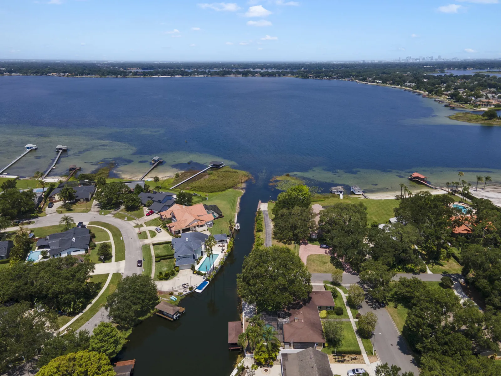
An aerial view of Belle Isle: lakefront homes and a narrow boat canal opening into the broad blue water of Lake Conway, with the Orlando skyline faint on the horizon.
Belle Isle, on the Conway chain — today
Belle Isle today, wrapped around Lake Conway (modern aerial). More than half the city is water. The town’s whole reason for being is the thing filling most of this photograph — and twice, keeping it was worth inventing a city over. Aerial photograph via Patrick Pixley / Belle Isle real estate listing.

On the ninth of September, 1977, a truck backed down to the edge of Lake Conway, in the suburbs just south of Orlando, and released thousands of live fish into the water. They weren’t bass or bream or anything a Florida angler would recognize. They were white amur — Chinese grass carp — and a federal agency had hauled them here on purpose, betting that a foreign fish was the only thing that could save the lake from a foreign weed.

To understand why anyone would do something that drastic to a quiet suburban lake, you have to know what this particular water meant to the town around it. The people here had already gone to absurd lengths to keep these lakes. Twice, they had invented a city to do it.

A city built to stop a drain

The Belle Isle area had been lived on for a very long time — the Timucua were here by about the ninth century. But the town, as a legal thing, was born out of an argument over water that nobody owned.

A black-and-white 1920s photograph of a large steam dredge sitting in a raw canal cut through Florida wetland, piling up the muck it has dug from the channel.
What draining a lake looked like — 1920s
A Florida drainage dredge at work in the 1920s (on the Tamiami Trail cut, southwest Florida — representative of the era, not Lake Conway). In boom-time Florida, draining and lowering wetlands was simply what you did with inconvenient water. Belle Isle was founded to make sure it didn’t happen here. Photograph via Wikimedia Commons.

In the 1920s, Orange County wanted to use the Conway chain of lakes for drainage — to lower them, to move water off the land around them. The families who lived on those lakes did not want their lakes turned into a county drain. So in 1924 they did the only thing that would actually stop it: they incorporated. If the lakes sat inside their own municipality, the county couldn’t simply pull the plug.

They called the place Belle Isle — close to the French for “beautiful island” — and a man named C. H. Hoffner served as its first mayor. The whole town was, in effect, a legal fence built around a body of water.

It didn’t hold the first time. In 1928 Belle Isle was annexed back into Orange County, and the City of Belle Isle simply stopped existing. The fence came down.

A town invented twice, for the same reason both times: so that no one upstream could decide to let the water out.

Then, in the early 1950s, the county floated the drainage idea again. And the lake people did exactly what their parents had done. They rallied, and in 1954 they reincorporated Belle Isle — this time for good. Florida formally recognized the city’s charter in 1972. The town has run continuously ever since, more than seven thousand people now, better than half of the city’s own area still open water.

The Belle Isle City Hall, a low tan masonry municipal building with a arched entrance and Florida landscaping, under a blue sky.
The city that only exists because of a lake
Belle Isle City Hall (modern photograph). The government here was created, dissolved, and created again around a single stubborn idea: that the chain of lakes belonged to the people who lived on it, not to whoever wanted to drain it. Photograph via Wikimedia Commons.

So that was settled. Belle Isle had won its lakes. What nobody on either side of the drainage fight had planned for was that the bigger threat to the water wouldn’t come from the county at all. It would come from a houseplant.

The weed that could fill a lake

In 1960, a plant called hydrilla got loose in the canals of south Florida — most likely dumped from an aquarium. It is a thin, feathery, bright-green strand of a thing, and in warm water it is close to unstoppable.

A close view of hydrilla: slender green stems ringed with whorls of small, saw-toothed leaves.
Hydrilla — the whole problem, up close
Hydrilla verticillata. A single fragment can start a new colony; the plant grows up from the lake bed toward the light and then mats out across the surface. Photograph via Wikimedia Commons.

Hydrilla roots in the lake bottom and grows straight up toward the sun, and when it reaches the surface it spreads sideways into a dense green mat. That mat can cut the light reaching the water below by as much as ninety-five percent — shading out every native plant, choking boat lanes, and turning open water into something you could almost walk on.

How fast? On Orange Lake, north of here, biologists watched hydrilla spread from a single hectare to more than a thousand hectares in three years — roughly ninety percent of the lake, gone green, in the time it takes to finish high school.

A person in a boat lifts a huge dripping mass of green hydrilla out of a Florida lake, the tangled stems spilling over the gunwale.
One armful, out of a whole lakeful
Hydrilla hauled from a central Florida lake. By the 1970s this plant was the single worst aquatic weed in the southeastern United States. Pulling it, cutting it, and poisoning it all had the same flaw: it grew back from the pieces left behind. Photograph via University of Florida / IFAS, Orange Lake.

You could cut it with machines, but the cut fragments floated off and started new colonies. You could spray it with herbicide, but it came back, and the chemicals went into the same water people swam in and drew from their wells. For a town that had twice refused to let its lakes be drained, watching them fill solid with weed was its own kind of losing the water.

The experiment on Lake Conway

In 1975 the U.S. Army Corps of Engineers’ Waterways Experiment Station started planning something that sounds, even now, slightly reckless: fight the imported plant with an imported animal. The white amur, or grass carp, is an Asian fish that does almost nothing but eat aquatic plants, all day, in enormous quantity. The idea was to put enough of them in a lake to graze the hydrilla down.

They needed a real, full-sized lake to try it on at scale — not a test pond. They chose Lake Conway.

A grass carp, or white amur: a large, heavy-bodied silver fish with big scales and a blunt head.
The white amur — a grazing machine
The white amur (Chinese grass carp), Ctenopharyngodon idella. A single adult can eat its own weight in plants and keep going. The gamble was that it would eat the hydrilla without stripping the lake of everything else. Photograph via Wikimedia Commons.

Lake Conway is not one lake but five connected pools — Lake Gatlin, the two arms of Little Lake Conway, and the north and south halves of Conway itself — about 1,800 acres of water in the middle of a growing suburb. The Corps spent a full year measuring everything living in it first, so they could tell later exactly what the fish had done. Then, on September 9, 1977, they stocked it.

The gray printed cover of a U.S. Army Corps of Engineers technical report titled about the large-scale operations management test of the white amur on Lake Conway, Florida.
The federal file on a suburban lake
The Corps of Engineers’ Lake Conway report, baseline volume. The “Large-Scale Operations Management Test” produced a shelf of these — the fish, the plants, the mammals, the waterfowl of one Orlando lake, measured year by year. U.S. Army Engineer Waterways Experiment Station, via Wikimedia Commons.

Two details made it less reckless than it sounds. First, the dose was deliberately light — only about four fish per acre. Second, every single fish was sterile. They were monosex stock, raised so they could not breed, which meant that if the plan went wrong the carp couldn’t multiply and escape into the rest of Florida. The Corps’ own model predicted the lake would come under control in about four years.

The reason for all that caution sat in the data from other Florida lakes. Stocked too heavily — two, three, four times Conway’s rate — grass carp didn’t just eat the hydrilla. They ate everything. The fish’s appetite ran so far ahead of the plants that lake after lake was left with no submerged vegetation at all: clear water, bare bottom, a different kind of dead.

An American coot, a slate-gray waterbird with a white bill, swimming on open water.
Everything downstream of the plants
An American coot (representative photograph). Coots and ducks on central Florida lakes feed directly on underwater plants like hydrilla. Strip a lake bare of vegetation and the problem doesn’t stop at the weed — it runs up the whole food chain. Photograph via Wikimedia Commons.

So Lake Conway was the careful version: enough fish to beat back the hydrilla, not so many that they’d scour the lake clean. It was a bet that you could aim an animal like a tool.

What the fish left behind

It worked — and, unusually, it worked the way they wanted it to. The grass carp brought the hydrilla under control while Lake Conway kept a varied community of native plants. Not a stripped lake, not a choked one. A managed one.

That restraint is why people still cite Lake Conway. The careful, sterile, low-dose version done here became a reference point for how grass carp could be used across the country — proof that the fish was a scalpel, not just a bomb, if you were disciplined about the dose.

Stand on the shore of Lake Conway now and none of this shows. It’s docks and boats and backyards, the Orlando skyline a smudge on the far side, the water open the way the people who built the town wanted it kept open.

What the whole story keeps circling back to is a single idea. Belle Isle was built on the stubborn conviction that a place should control the water it can’t live without — not hand it to the county to drain, not surrender it to a weed. The county plan, the hydrilla, the strange autumn when the government released thousands of fish they had to sterilize first: every chapter is the same town, refusing, one more time, to lose its lakes.

A present-day note · GENERasic

Belle Isle’s whole history is one lesson told twice: don’t leave the thing you can’t live without in someone else’s hands. A modern home runs on power the way this town runs on its lakes.

For a hundred years, Belle Isle’s answer to a threatened lake was to take control of it — incorporate, measure, manage, intervene — instead of hoping the problem would leave on its own. The county’s drain and the hydrilla had the same shape: something you depend on completely, put at risk by a force you don’t command.

A house in Florida depends on electricity exactly that way. Cooling, clean water, refrigeration, medical equipment — nearly everything that keeps a home livable runs on power, and in a hurricane the grid is the first thing to go down. That’s a when, not an if. No amount of building quality keeps the lights on when the line down the street is on the ground.

A standby generator is the version of that control you can wire up ahead of time: it starts itself the moment the power drops, whether anyone’s home or not. In a Florida outage, here’s what it’s actually holding up:

An enclosed residential standby generator on a concrete pad beside a building, with trees behind it.
The fallback, wired before you need it
A residential standby generator (representative photograph, not Belle Isle equipment) — wired to start on its own the moment the grid drops. Via Wikimedia Commons.

Which of those actually apply to your address — your medical needs, how your house is fed, well or city water — is worth pinning down for your own home rather than guessing. That part is yours to check.

You can get an address-specific installed price for standby power — the whole turnkey number, not a callback and a maybe — in one sitting.

Get your installed price for this address→
Sources & Photo Credits

On the history

Note on the chosen lens and on uncertainties

This page was built with a “power resilience” lens for GENERasic. Belle Isle has no documented electricity or power-utility history of its own, so the lens is carried in the present-day GENERasic note at the end rather than forced into the history; the historical through-line is Belle Isle’s century-long fight to keep control of the Conway chain of lakes — first against being drained, then against being overrun by hydrilla. A few points are stated carefully rather than dramatized. The city’s own site gives the reason for both the 1924 founding and the 1954 reincorporation as Orange County’s plan to “use the lakes for drainage”; the specific engineering purpose of that drainage (flood control, land development, mosquito abatement) is not spelled out in the sources used here, so it is described only as the county wanting to lower/drain the lakes. Lake Conway was selected by the Corps as a representative urban study lake for the Large-Scale Operations Management Test; hydrilla had a foothold there (dominant in the West Pool at baseline) but the lake was not wholly choked — the dramatic “1 ha to over 1,000 ha” spread is documented for Orange Lake, to the north, and is used here to show what hydrilla does, not to describe Lake Conway itself. The 1977 stocking is described in sources both as about four fish per acre (Corps, Table 1) and about ten per hectare of lake (Hoyer et al.); these are the same order of magnitude (a hectare is about 2.47 acres). No single reliable total count of fish stocked is quoted here; the figure would be an inference from rate times area. The claim that Lake Conway “first” used grass carp is avoided — experimental Florida stockings date to 1972; Lake Conway was the Corps’ large-scale operational test, and is cited as a model for restrained, selective stocking.

Photographs

  1. Belle Isle on the Conway chain, today (hero) — modern aerial of Belle Isle’s lakefront homes, a boat canal, and Lake Conway with the Orlando skyline beyond. Aerial photograph via Patrick Pixley (Belle Isle real estate listing). File: belle-isle-lake-conway-aerial-today. Source: patrickpixley.com.
  2. Florida drainage dredge, 1920s (representative) — a steam dredge cutting the Tamiami Trail canal in southwest Florida; used to show what draining Florida wetland looked like in the founding era, not a photograph of Lake Conway. Via Wikimedia Commons. File: florida-dredge-tamiami-1920s. Commons
  3. Belle Isle City Hall (modern) — the seat of the government that was created, dissolved, and re-created around the lakes. Via Wikimedia Commons. File: belle-isle-city-hall-today. Commons
  4. Hydrilla verticillata, close up — the invasive aquatic weed itself: slender stems in whorls of saw-toothed leaves. Via Wikimedia Commons. File: hydrilla-plant-closeup. Commons
  5. Hydrilla hauled from a central Florida lake — a dripping mass of hydrilla lifted into a boat, showing the scale of a single colony. University of Florida / IFAS (Orange Lake). File: hydrilla-pulled-from-florida-lake. Source: blogs.ifas.ufl.edu.
  6. White amur / Chinese grass carp (Ctenopharyngodon idella) — the plant-eating fish stocked into Lake Conway in 1977. Via Wikimedia Commons. File: white-amur-grass-carp. Commons
  7. Corps of Engineers Lake Conway report (baseline volume cover) — cover of the U.S. Army Engineer Waterways Experiment Station’s Large-Scale Operations Management Test report on the aquatic macrophytes of Lake Conway. Via Wikimedia Commons. File: lsomt-corps-report-lake-conway-1978. Commons
  8. American coot (representative) — a waterbird of the kind that feeds on submerged plants like hydrilla on central Florida lakes; photographed elsewhere, used to illustrate the food chain, not a Lake Conway photograph. Via Wikimedia Commons. File: american-coot-representative. Commons
  9. Standby generator (representative — not Belle Isle equipment) — an enclosed residential standby generator on a pad. Via Wikimedia Commons. File: standby-generator-set-representative.

The dredge photograph is archival (1920s); the city hall, lake aerial, hydrilla, grass carp, and coot are modern photographs of the real subjects (the coot and dredge are labeled representative, photographed outside Belle Isle). The report cover is a scanned U.S. Government document. No image’s factual content was altered — the Polaroid frames and handwritten notes are CSS added around the photographs, never onto them. Original downloads and a full research record are kept alongside this page in assets/images/originals/ and source-record.md. Any owner who wants an image removed need only ask.