Windermere, Florida  ·  A Local History

The Town That Wouldn’t
Pave Its Roads


For more than a century Windermere has defended its sand roads and its oak canopy by law — staying small, shaded, and hard to cross on purpose. The same shade that makes it beautiful is what hands its lights to the next storm.

Bolted to a post on a sand road fourteen miles west of downtown Orlando, there is a sign that tells you almost everything about the town behind it. It reads: Local Traffic Only. 7 AM to 9 AM, 3 PM to 6 PM. $200 Fine. Windermere Ord. #2004-07. Behind it the road is not paved. It is pale Florida sand, rutted by tires, running off under a ceiling of live oaks.

Read it again and notice what it is: a law a town wrote to make itself harder to drive through. In 2004, while every other place in Central Florida was widening lanes and pouring asphalt to keep up with Orlando’s sprawl, Windermere spent its effort keeping cars out and its roads unpaved.

Which raises the question the rest of this is about: why would a place fight this hard to stay small, slow, and in the trees — and what does a town pay for that?
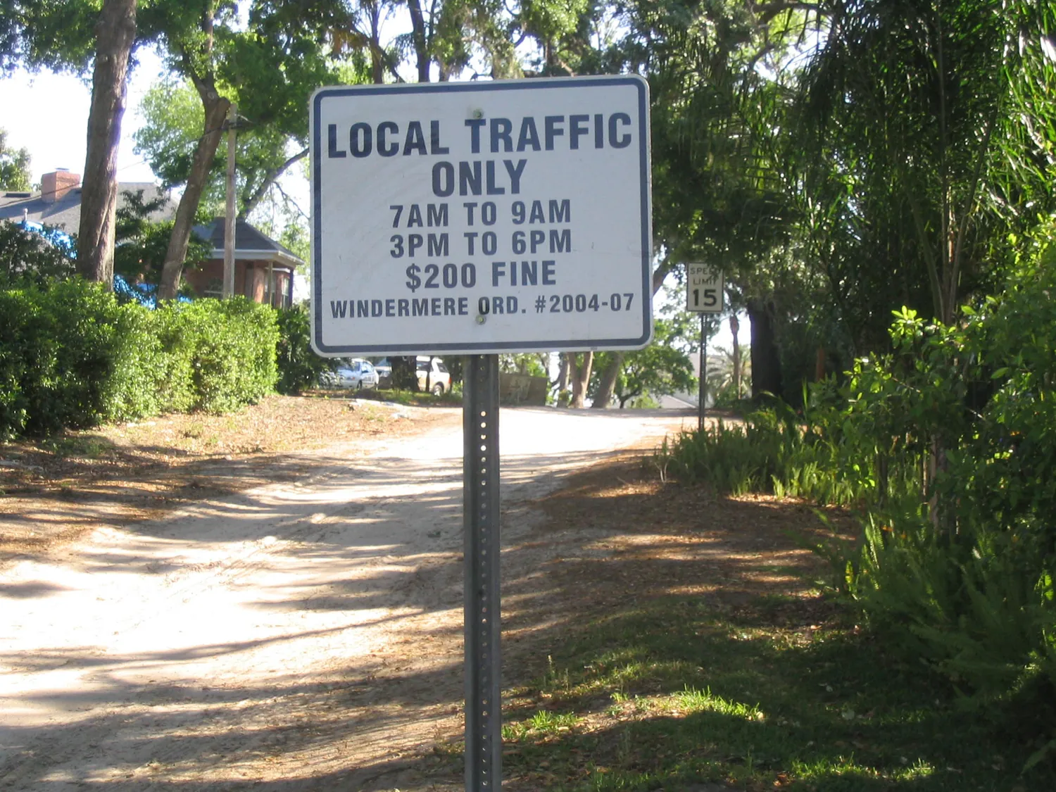
A white 'Local Traffic Only' sign on a metal post, citing Windermere Ordinance #2004-07 and a $200 fine, standing beside an unpaved sand road that runs off under a canopy of trees.
Windermere today
“$200 fine to cut through”
A sand lane off Main Street, present day, posted under Ordinance #2004-07. Photograph by Wikimedia user “SPUI,” released to the public domain.

A lake named for a lake, 4,000 miles away

Before any of it, there was pine flatwoods and water. The high ground here is a narrow neck of land threaded between big lakes, and in the 1880s an Englishman looked at it and named it after a place he’d left: Windermere, the largest lake in England’s Lake District. Land was bought around 1885; a town was drawn on paper in 1889. Then, for a long while, almost nothing happened.

A single-story log cabin standing in an open field among oaks draped with Spanish moss, a rough fence in front.
“Vacant 1910”
A log cabin near Windermere, noted on the print as “vacant 1910, use by Palmer & McMurtrey.” Images of Central Florida, Orange County Library System / UCF Libraries.

What survives from those years is modest: a cabin standing empty in a field of moss-hung oaks, the kind of place a settler put up and then thought better of. For two decades the name on the map was mostly a hope. The town that exists now wasn’t built by the man who named it. It was built by a man with a sawmill.

The man with the sawmill

His name was Cal Palmer. Around 1911 Palmer and a partner, Dr. J. A. Johnson, put together roughly two thousand acres — some of it picked up for pennies through unpaid-tax certificates — and bought the whole block for about $10,000. They called themselves the Windermere Improvement Company, and this time somebody actually improved it.

Palmer hauled his sawmill down from Ohio and started cutting local pine into a town. He built himself a house, and a small sales office to sell the lots.

Two women in long dresses standing at the arched wooden gate of a picket fence, a frame house behind them.
Kate & Mrs. Palmer at the gate
Cal Palmer’s house, Windermere, with Kate and Mrs. Palmer at the front gate, early 1900s. Images of Central Florida, Orange County Library System / UCF Libraries.

That little office did a lot of jobs. It was the town’s post office from 1911 to 1926. It stayed the Improvement Company’s sales desk until the company was wound up in 1937. And when Windermere finally incorporated as a town — February 2, 1925 — the same building served as its makeshift seat of government, because the new town had nowhere else to meet.

In 1920 Palmer rounded up the growers into the Windermere Citrus Growers Association. That tells you what the place ran on underneath the shade: oranges. The money came out of the groves. The groves is where everyone else’s money came from too.

A hand-tinted color postcard looking across rows of orange trees toward two lakes and a cluster of buildings, labeled by hand 'Howe grove' and 'Thornton House.'
The money grew on trees — 1904
“Orange Grove and Pineries, Orlando, Fla.,” Detroit Photographic Co., 1904 — a grove in the lake country just east of Windermere. Images of Central Florida, Orange County Library System / UCF Libraries.

What people actually came for

But the thing Windermere was really selling wasn’t citrus. It was the water and the trees. The town sits on an isthmus wedged between Lake Butler and Lake Down, part of a run of eleven connected lakes — the Butler Chain — that Florida would one day protect by name as Outstanding Florida Waters. People came to live on the lakes, under the oaks, away from everything.

A lakeside garden in bloom with a low bridge, cypress and oaks draped in Spanish moss, and open water visible beyond the trees.
A garden on Lake Butler
The Rev. John Ischy’s garden, on the Lake Butler shore in Windermere, early 1900s. Images of Central Florida, Orange County Library System / UCF Libraries.

You can see it in a photograph of the Reverend John Ischy’s yard — a garden running down to Lake Butler, cypress and oak hung with moss, water behind the trees. That picture is the whole pitch. Not a resort, not a boardwalk. A shaded lot on quiet water.

By the 1920s the town was settled enough to want a proper meeting place, and the women got there first. The Windermere Woman’s Club put up a two-story clapboard clubhouse on the Lake Butler shore in 1922–24.

A two-story white clapboard building with dormer windows, standing among tall pines near a lake, on bare sandy ground.
The Woman’s Club, built 1922–24
The Windermere Woman’s Club building, erected 1922–24 near Lake Butler. Images of Central Florida, Orange County Library System / UCF Libraries.

It was moved to the center of town in 1938 and handed to the town in 1945 to be Town Hall — which it still is. Remember the building. It comes back at the end.

The town, drawn in sand

Here is the map that gives the game away. It was drawn to explain a 2004 traffic change, but look past that at what it shows in gray: nearly every street in Windermere is a dirt road. Only a couple of lines are red for paved. The grid sits on its neck of land with Lake Butler on one side, Lake Down on the other, Lake Bessie below — a town you can barely get into without meaning to.

A detailed map of downtown Windermere between Lake Butler, Lake Down, and Lake Bessie, with a legend showing almost every street as a gray dirt road and only two as paved, plus all-way stops and local-traffic-only points.
Mapped 2005
Gray means dirt. Almost all of it is gray.
Downtown Windermere street map, drawn to show the 2005 traffic pattern after Main Street was bricked and two roundabouts added. In the legend, gray is dirt road, red is paved. Wikimedia Commons, public domain.

None of this is an accident of a town too poor to pave. Windermere decided to stay this way. Sand roads slow traffic to the posted fifteen miles an hour, and they let rain soak straight into the ground instead of sheeting oil and grit into the Butler Chain. When Orlando’s growth finally arrived next door — Disney opened a few miles away in 1971; some of Florida’s priciest gated estates rose just outside the town line — Windermere answered by digging in harder.

In 2004 it did pave and brick its one downtown crossing, Main Street, and dropped in a pair of roundabouts to calm it. Then, the same year, it passed Ordinance #2004-07 — the one on the sign — making it a finable offense to use its sand streets as a shortcut during rush hour. The money went toward being harder to cross, not easier.

A town that spent its money to stay slow, unpaved, and hard to reach — and got exactly the beautiful, shaded, fragile place it paid for.

A grassy lakefront park with palms and a moss-draped oak framing open water, a dock and boathouse at the shore under a bright sky.
Windermere today
Still the lakes. Still the point.
Lake Down Park, on the Butler Chain of Lakes, present day. Photograph courtesy of the Town of Windermere.

The bill the trees send

Here is the cost. A canopy of century-old live oaks doesn’t only shade the lane. It also sits directly on top of the power lines strung along it. A town that chose trees over clearance, sand over asphalt, and narrow over wide has built, without quite saying so, a town where the lights are only ever one storm from going out.

That bill came due in the same year as the sign. On August 13, 2004, Hurricane Charley came ashore in southwest Florida as a Category 4 and drove straight up the Interstate 4 corridor through the Orlando area — an inland track almost no one expected a hurricane to take. Across Central Florida’s lake towns, enormous old oaks that had never felt that kind of wind came down, and where the oaks went, they took the power lines, the poles, and the quiet with them.

A storm-track map showing Hurricane Charley crossing Cuba, making landfall in southwest Florida at peak intensity, then cutting inland up through Central Florida and out the Carolinas.
Charley came inland — August 2004
Track of Hurricane Charley, August 2004 — a Category 4 that came ashore in southwest Florida and ran up the peninsula through the Orlando area. National Hurricane Center data; map via Wikimedia Commons, public domain.

For a canopy town, that is the whole trade in a single night. The crews that had to come fix it were doing it in the dark, down unlit sand lanes, under the same trees that had just dropped on the wires.

What the sign is really for

So go back to the sign. The $200 fine isn’t crankiness about traffic. It’s a town paying, on purpose and in public, to stay the kind of place it is — and quietly accepting the bill that comes with that choice. Windermere never buried its wires the way some towns did. It did the opposite. It planted over them, and kept planting, and wrote the shade into law.

The clapboard Woman’s Club is still Town Hall, moved twice and still standing. The lakes are still Outstanding Florida Waters. The roads are still sand.

The white clapboard Windermere Town Hall today, with the same dormers and a columned portico, shaded by pines and oaks, benches on a paved forecourt.
Windermere today
The 1922 clubhouse — still Town Hall
Windermere Town Hall, present day — the 1922–24 Woman’s Club building, moved to the town center in 1938 and the seat of government since 1945. Photograph by Wikimedia user “Ebyabe,” CC BY 2.5.

A hundred and eighty-one people lived here in 1930; about three thousand do now, which by Central Florida standards means almost no one. Windermere looked at the fastest-growing stretch of Florida, decided it would rather be shaded than convenient, and spent a century making that stick — one unpaved street, one planted oak, one $200 sign at a time. The beauty and the darkness come from the same decision. Out here, the two were always the same bill.

A present-day note · GENERasic

Windermere planted its canopy over the wires. That canopy still comes down.

Everything that makes Windermere Windermere is also what puts its power at risk. The oaks that roof the lanes sit on the lines. The sand roads that keep cars out slow a line crew down just as much. Charley proved it in 2004, and nothing about the trees or the wires has changed since.

Here’s the part that’s just common sense: the one piece of this a homeowner actually controls is their own standby power — the unit in the side yard that doesn’t care what the grid, or the oak across the street, just did.

And on these big lakefront lots, losing power costs more than a hot house. The mechanics are worth knowing before the storm, not during it:

How much of that actually lands on your address — your well, your gate, whether you sit at the low end of a lift station — is worth confirming for your own home rather than guessing at. That part is yours to check.

The rest is the same bargain Windermere has been making for a hundred years: handle it before you need it. You can get an address-specific installed price for standby power — the whole turnkey number, not a callback and a maybe — in one sitting.

Get your installed price for this address→
Sources & Photo Credits

On the history

Photographs & documents

  1. Sand lane with “Local Traffic Only” sign (Ordinance #2004-07), Windermere — present day; photograph by Wikimedia Commons user “SPUI,” public domain. Modern photograph. File: windermere-sand-road-local-traffic-sign. Commons
  2. Log cabin near Windermere — marked “vacant 1910, use by Palmer & McMurtrey”; Images of Central Florida (DP0004896), Orange County Library System, digitized by UCF Libraries. File: windermere-log-cabin-circa-1910. stars.library.ucf.edu/cfm-images/1897
  3. Cal Palmer’s house, with Kate and Mrs. Palmer at the gate, Windermere — early 1900s; Images of Central Florida, Orange County Library System / UCF Libraries. File: cal-palmer-house-kate-and-mrs-palmer. stars.library.ucf.edu/cfm-images/1939
  4. “Orange Grove and Pineries, Orlando, Fla.” — hand-tinted postcard, Detroit Photographic Co., 1904; a grove in the lake country just east of Windermere (regional context). Images of Central Florida (DP0004980 area), Orange County Library System / UCF Libraries. File: orlando-orange-grove-pineries-1904. stars.library.ucf.edu/cfm-images/1981
  5. The Rev. John Ischy’s garden on Lake Butler, Windermere — early 1900s; Images of Central Florida, Orange County Library System / UCF Libraries. File: rev-ischy-lakeside-garden. stars.library.ucf.edu/cfm-images/1929
  6. Windermere Woman’s Club building — built 1922–24 near Lake Butler (now Town Hall); Images of Central Florida, Orange County Library System / UCF Libraries. File: windermere-womens-club-1922. stars.library.ucf.edu/cfm-images/1893
  7. Downtown Windermere street map (2005 traffic pattern) — shows the dirt-road grid between Lake Butler, Lake Down, and Lake Bessie after Main Street was bricked and two roundabouts added; Wikimedia Commons, public domain. File: windermere-dirt-road-map-2005. Commons
  8. Lake Down Park, Windermere — present day; photograph courtesy of the Town of Windermere, public domain. Modern photograph. File: lake-down-windermere-today. Commons
  9. Track of Hurricane Charley — August 2004; National Hurricane Center best-track data plotted on a NASA Blue Marble basemap; via Wikimedia Commons, public domain. File: hurricane-charley-track-2004. Commons
  10. Windermere Town Hall today — the 1922–24 Woman’s Club building; photograph by Wikimedia Commons user “Ebyabe,” CC BY 2.5. Modern photograph. File: windermere-town-hall-today. Commons

Original downloads and a full research record are kept alongside this page in assets/images/originals/ and source-record.md. Historical images here are shown with modern ones clearly labeled; no archival photograph was altered in any way that changes its factual content. The Polaroid frames and handwritten notes are CSS, added around the photographs, never onto them.